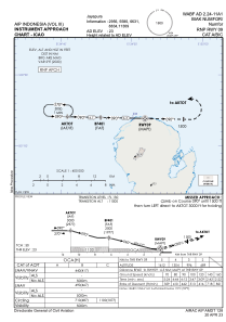
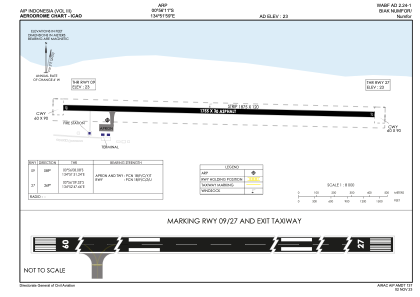


WABF - Biak Numfor / Numfor
Located in , Indonesia
ICAO - , IATA - FOO
Data provided by AirmateGeneral information
Coordinates: S0°56'11" E134°51'59"
Elevation is 23 feet MSL.
View others Airports in Papua
Operational data
Special qualification required
Current time UTC:
Current local time:
Weather at : - ( 0 km )
METAR: LWSK 040650Z 30003KT 220V350 8000 RA BKN036 OVC070 12/11 Q1009 NOSIG
Communications frequencies: [VIEW]
Runways:
| RWY identifier | QFU | Length (ft) | Width (ft) | Surface | LDA (ft) |
| 09 | 91° | 5758 | 98 | UNK | |
| 27 | 271° | 5758 | 98 | UNK |
Airport contact information
Address: Indonesia