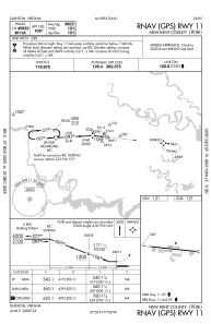
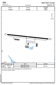


W96 - New Kent County
Located in Quinton, United States
ICAO - W96, IATA -
Data provided by AirmateGeneral information
Coordinates: N37°30'12" W77°7'36"
Elevation is 121 feet MSL.
Magnetic variation is -10° East View others Airports in Virginia
Operational data
Special qualification required
Current time UTC:
Current local time:
Weather at : KRIC - Richmond Intl ( 17 km )
METAR: KRIC 090654Z 23007KT 10SM BKN200 21/17 A2971 RMK AO2 SLP063 T02110167
TAF: KRIC 090540Z 0906/1006 24005KT P6SM BKN150 FM091000 26006KT P6SM VCSH BKN050 FM091500 23008KT P6SM SCT050 BKN080 FM092100 19009KT 5SM -SHRA VCTS BKN040CB FM100100 06007KT 5SM -RA BR OVC025
Communications frequencies: [VIEW]
Runways:
| RWY identifier | QFU | Length (ft) | Width (ft) | Surface | LDA (ft) |
| 11 | 96° | 3602 | 75 | ASPH | |
| 29 | 276° | 3602 | 75 | ASPH |
Airport contact information
Address: Quinton United States