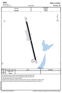


W90 - New London
Located in Forest, United States
ICAO - W90, IATA -
Data provided by AirmateGeneral information
Coordinates: N37°16'18" W79°20'9"
Elevation is 842 feet MSL.
Magnetic variation is -09° East View others Airports in Virginia
Operational data
Special qualification required
Current time UTC:
Current local time:
Weather at : KLYH - Lynchburg Rgnl/Preston Glenn Fld ( 13 km )
METAR: KLYH 090454Z AUTO VRB05KT 10SM CLR 21/14 A2979 RMK AO2 SLP078 T02060144 402890172
TAF: KLYH 090526Z 0906/1006 VRB04KT P6SM BKN150 FM090700 VRB03KT 5SM -RA BKN025 FM091000 21005KT P6SM VCSH OVC010 FM091200 23008KT P6SM SCT050 FM100200 29006KT P6SM OVC025
Communications frequencies: [VIEW]
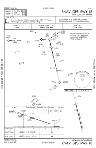
Runways:
| RWY identifier | QFU | Length (ft) | Width (ft) | Surface | LDA (ft) |
| 18 | 167° | 3164 | 40 | ASPH | |
| 36 | 347° | 3164 | 40 | ASPH |
Airport contact information
Address: Forest United States