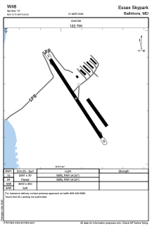


W48 - Essex Skypark
Located in Baltimore, United States
ICAO - W48, IATA -
Data provided by AirmateGeneral information
Coordinates: N39°15'45" W76°25'56"
Elevation is 14 feet MSL.
Magnetic variation is -10° East View others Airports in Maryland
Operational data
Special qualification required
Current time UTC:
Current local time:
Weather at : KMTN - Martin State ( 7 km )
METAR: KMTN 091445Z 00000KT 10SM -RA OVC100 20/12 A2977
TAF: KMTN 091125Z 0912/1012 00000KT P6SM FEW080 BKN250 FM091300 05007KT P6SM VCSH OVC070 FM091900 06009KT 6SM -SHRA OVC030 FM092200 06010KT 6SM -SHRA OVC015 FM100300 08007KT 6SM -SHRA BR OVC008
Communications frequencies: [VIEW]
Runways:
| RWY identifier | QFU | Length (ft) | Width (ft) | Surface | LDA (ft) |
| 16 | 147° | 2081 | 30 | ASPH | |
| 34 | 327° | 2081 | 30 | ASPH | |
| 16W | 0° | 3000 | 300 | WATER | |
| 34W | 0° | 3000 | 300 | WATER |
Airport contact information
Address: Baltimore United States