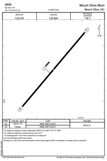


W40 - Mount Olive Muni
Located in Mount Olive, United States
ICAO - W40, IATA -
Data provided by AirmateGeneral information
Coordinates: N35°13'17" W78°2'19"
Elevation is 167 feet MSL.
Magnetic variation is -09° East View others Airports in North Carolina
Operational data
Special qualification required
Current time UTC:
Current local time:
Weather at : KGSB - Seymour Johnson Afb ( 15 km )
TAF: TAF KGSB 080400Z 0804/0910 23006KT 9999 FEW035 SCT055 WS020/24032KT QNH2972INS TEMPO 0805/0812 8000 BR BECMG 0814/0815 25012G18KT 9999 FEW040 BKN055 QNH2972INS BECMG 0818/0819 25015G20KT 8000 -SHRA BKN030 BKN090 QNH2970INS TEMPO 0820/0823 24020G30KT 6000 TSRA OVC030CB BECMG 0823/0824 22006KT 9999 NSW BKN030 OVC045 QNH2972INS BECMG 0905/0906 21009KT 8000 BR SCT008 BKN015 QNH2971INS TX32/0820Z TN21/0808Z
Communications frequencies: [VIEW]
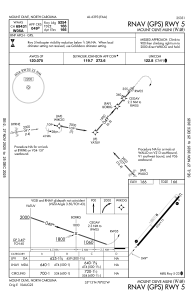
Runways:
| RWY identifier | QFU | Length (ft) | Width (ft) | Surface | LDA (ft) |
| 05 | 40° | 5254 | 75 | ASPH | |
| 23 | 220° | 5254 | 75 | ASPH |
Airport contact information
Address: Mount Olive United States
