


W16 - First Air Fld
Located in Monroe, United States
ICAO - W16, IATA -
Data provided by AirmateGeneral information
Coordinates: N47°52'17" W121°59'43"
Elevation is 50 feet MSL.
Magnetic variation is 20° East View others Airports in Washington
Operational data
Special qualification required
Current time UTC:
Current local time:
Weather at : KPAE - Seattle Paine Fld Intl ( 22 km )
METAR: KPAE 090853Z 03003KT 10SM CLR 11/05 A3038 RMK AO2 SLP288 T01110050 58002
TAF: KPAE 090537Z 0906/1006 35006KT P6SM SKC FM091900 34009KT P6SM SKC FM100400 01006KT P6SM SKC
Communications frequencies: [VIEW]
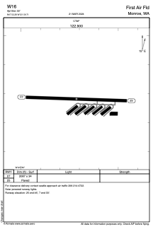
Runways:
| RWY identifier | QFU | Length (ft) | Width (ft) | Surface | LDA (ft) |
| 07 | 92° | 2087 | 34 | ASPH | |
| 25 | 272° | 2087 | 34 | ASPH |
Airport contact information
Address: Monroe United States
