
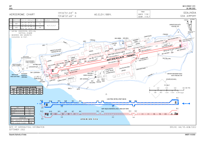


VOGO - Goa International Airport, Dabolim, Goa (Navy)
Located in Panaji, India
ICAO - , IATA - GOI
Data provided by AirmateGeneral information
Coordinates: N15°22'51" E73°49'37"
Elevation is 187 feet MSL.
View others Airports in Goa
Operational data
Special qualification required
Current time UTC:
Current local time:
Weather
TAF: TAF VOGO 220200Z 2203/2212 04006KT 6000 FEW020 SCT080 TEMPO 2205/2209 27010G20KT TEMPO 2210/2212 30010G20KT 4000 -TSRA FEW010 FEW025TCU/CB BKN080
Communications frequencies: [VIEW]
Runways:
| RWY identifier | QFU | Length (ft) | Width (ft) | Surface | LDA (ft) |
| 08 | 79° | 11240 | 148 | UNK | |
| 26 | 259° | 11240 | 148 | UNK |
Airport contact information
Address: Panaji India