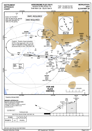
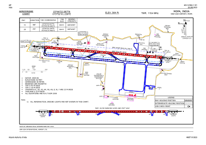


VOGA - Manohar International Airport-Mopa, Goa
Located in Mopa, India
ICAO - , IATA - GOX
Data provided by AirmateGeneral information
Coordinates: N15°44'33" E73°52'1"
Elevation is 564 feet MSL.
View others Airports in Goa
Operational data
Special qualification required
Current time UTC:
Current local time:
Weather at : VOGO - Goa International Airport, Dabolim, Goa (Navy) ( 40 km )
METAR: VOGO 211330Z 31009KT 6000 SCT020 BKN080 31/26 Q1003 NOSIG
TAF: TAF VOGO 211100Z 2112/2121 30010KT 6000 SCT020 SCT080 TEMPO 2114/2118 06010G20KT 4000 -TSRA FEW010 FEW025CB BKN080 TEMPO 2120/2121 03006KT
Communications frequencies: [VIEW]
Runways:
| RWY identifier | QFU | Length (ft) | Width (ft) | Surface | LDA (ft) |
| 10 | 95° | 11483 | 148 | UNK | |
| 28 | 275° | 11483 | 148 | UNK |
Airport contact information
Address: Mopa India