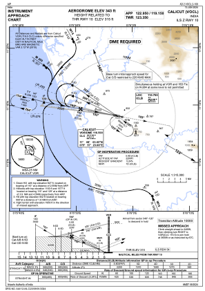
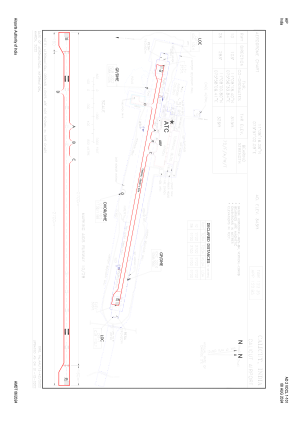


VOCL - Calicut Airport, Calicut
Located in Calicut, India
ICAO - VOCL, IATA - CCJ
Data provided by AirmateGeneral information
Coordinates: N11°8'16" E75°57'2"
Elevation is 342 feet MSL.
View others Airports in Kerala
Operational data
Special qualification required
Current time UTC:
Current local time:
Weather
METAR: VOCL 210930Z 22005KT 6000 DZ FEW008 SCT012 BKN080 29/24 Q1002 TEMPO 5000 -RA
TAF: TAF VOCL 210800Z 2109/2118 25005KT 6000 SCT015 BKN080 TEMPO 2109/2113 35010KT 3000 TSRA RA SCT010 FEW025CB OVC080 BECMG 2113/2114 10005KT 3000 HZ -RA SCT012 SCT080
Communications frequencies: [VIEW]
Runways:
| RWY identifier | QFU | Length (ft) | Width (ft) | Surface | LDA (ft) |
| 10 | 101° | 9383 | 148 | ASP | |
| 28 | 281° | 9383 | 148 | ASP |
Airport contact information
Address: Calicut India