


VOCB - Coimbatore Airport, Coimbatore
Located in Coimbatore, India
ICAO - VOCB, IATA - CJB
Data provided by AirmateGeneral information
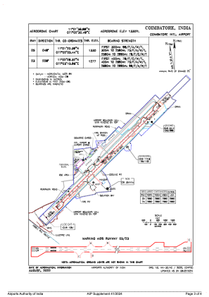
Coordinates: N11°1'37" E77°2'30"
Elevation is 1328 feet MSL.
View others Airports in Tamil Nadu
Operational data
Special qualification required
Current time UTC:
Current local time:
Weather
METAR: VOCB 152300Z VRB02KT 4000 BR SCT012 BKN080 25/24 Q1012 NOSIG
TAF: TAF VOCB 151700Z 1518/1624 27005KT 4000 BR FEW015 TEMPO 1518/1524 3000 TSRA/RA FEW012 FEW020TCU/CB BKN080 BECMG 1521/1522 VRB02KT BECMG 1603/1604 5000 BR BECMG 1606/1607 6000 TEMPO 1606/1612 3000 TSRA/RA FEW012 FEW020TCU/CB BKN080 BECMG 1612/1613 5000 BR
Communications frequencies: [VIEW]
Runways:
| RWY identifier | QFU | Length (ft) | Width (ft) | Surface | LDA (ft) |
| 05 | 46° | 9810 | 148 | ASP | |
| 23 | 226° | 9810 | 148 | ASP |
Airport contact information
Address: Coimbatore India