
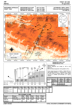
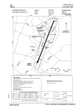


VNKT - Tribhuvan Intl
Located in Kathmandu, Nepal
ICAO - VNKT, IATA - KTM
Data provided by AirmateGeneral information
Coordinates: N27°41'46" E85°21'38"
Elevation is 4395 feet MSL.
View others Airports in Bagmati
Operational data
Special qualification required
Current time UTC:
Current local time:
Weather
METAR: VNKT 230030Z 08004KT 7000 FEW015 SCT030 BKN100 21/17 Q1014 NOSIG
TAF: TAF VNKT 222300Z 2300/2324 16003KT 6000 FEW015 SCT030 BKN100 BECMG 2301/2303 VRB02KT 5000 BR FEW015 SCT030 BKN100 PROB30 2301/2304 VRB10KT 5000 -TSRA FEW025CB BECMG 2304/2305 23005KT 7000 FEW015 SCT030 BECMG 2307/2309 24011KT 8000 FEW015 SCT030 BKN100 PROB40 2307/2312 VRB14KT 6000 -TSRA/RA FEW025CB BECMG 2315/2316 15003KT 7000 FEW015 SCT030 BKN100
Communications frequencies: [VIEW]
Runways:
| RWY identifier | QFU | Length (ft) | Width (ft) | Surface | LDA (ft) |
| 02 | 22° | 10085 | 148 | ASP | |
| 20 | 202° | 10085 | 148 | ASP |
Airport contact information
Address: Kathmandu Nepal