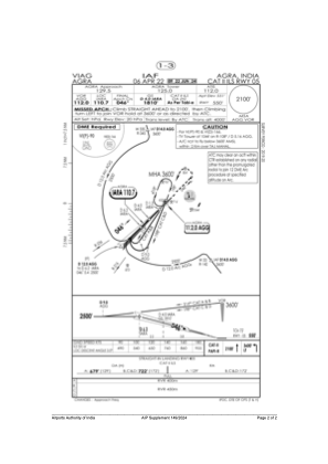


VIAG - Agra/Indian Air Force
Located in Agra, India
ICAO - VIAG, IATA - AGR
Data provided by AirmateGeneral information
Coordinates: N27°9'33" E77°57'38"
Elevation is 548 feet MSL.
View others Airports in Uttar Pradesh
Operational data
Special qualification required
Current time UTC:
Current local time:
Weather
TAF: TAF VIAG 210500Z 2106/2212 10007KT 6000 FEW100 TEMPO 2108/2112 30010G20KT 5000 DU SCT025 FEW030TCU SCT100 TX45/09Z TEMPO 2201/2203 VRB02KT 5000 DU TEMPO 2208/2212 30010G20KT 5000 DU SCT025 FEW030TCU SCT100 TX44/09Z
Communications frequencies: [VIEW]
Runways:
| RWY identifier | QFU | Length (ft) | Width (ft) | Surface | LDA (ft) |
| 05 | 46° | 9403 | 148 | CON | |
| 23 | 226° | 9403 | 148 | CON | |
| 12 | 116° | 6001 | 148 | CON | |
| 30 | 296° | 6001 | 148 | CON |
Airport contact information
Address: Agra India