


VEIM - Imphal Airport, Imphal
Located in Imphal, India
ICAO - VEIM, IATA - IMF
Data provided by AirmateGeneral information
Coordinates: N24°45'52" E93°53'59"
Elevation is 2540 feet MSL.
View others Airports in Manipur
Operational data
Special qualification required
Current time UTC:
Current local time:
Weather
METAR: VEIM 211400Z 30005KT 4000 BR SCT018 BKN100 23/22 Q1011 NOSIG
TAF: TAF VEIM 211100Z 2112/2218 00000KT 5000 BR SCT018 BKN100 BECMG 2115/2117 3000 RA BR SCT016 FEW025CB BKN090 BECMG 2204/2206 21005KT 5000 HZ FEW018 SCT100 BECMG 2212/2214 00000KT
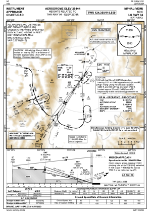
Communications frequencies: [VIEW]
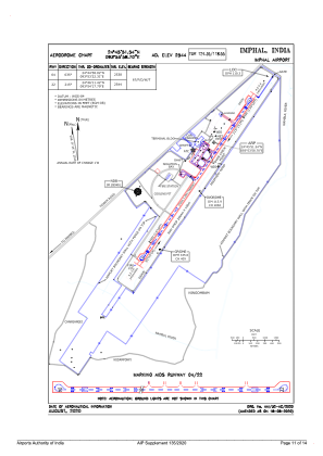
Runways:
| RWY identifier | QFU | Length (ft) | Width (ft) | Surface | LDA (ft) |
| 04 | 35° | 9003 | 148 | ASP | |
| 22 | 215° | 9003 | 148 | ASP |
Airport contact information
Address: Imphal India