


UTAK - Turkmenbashi
Located in Turkmenbashi, Turkmenistan
ICAO - UTAK, IATA - KRW
Data provided by AirmateGeneral information
Coordinates: N40°3'48" E53°0'26"
Elevation is 285 feet MSL.
View others Airports in Balkan
Operational data
Special qualification required
Current time UTC:
Current local time:
Weather
METAR: UTAK 180100Z 32010KT 9999 BKN035 12/10 Q1016 R34L/29//50 NOSIG
TAF: TAF UTAK 172230Z 1800/1824 29018G28KT 2500 -SHRA BR BKN007 SCT030CB BKN100 TEMPO 1800/1803 27016KT 0800 FG VV001 BECMG 1803/1804 9999 NSW BKN013 BKN100 TEMPO 1804/1810 34020G30KT
Communications frequencies: [VIEW]
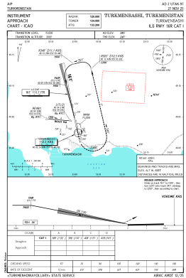
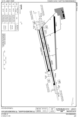
Runways:
| RWY identifier | QFU | Length (ft) | Width (ft) | Surface | LDA (ft) |
| 16L | 166° | 8202 | 144 | UNK | |
| 34R | 346° | 8202 | 144 | UNK | |
| 16R | 166° | 11483 | 148 | UNK | |
| 34L | 346° | 11483 | 148 | UNK |
Airport contact information
Address: Turkmenbashi Turkmenistan