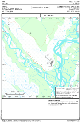


UHAL - Lamutskoye
Located in Lamutskoe, Russian Federation
ICAO - , IATA -
Data provided by AirmateGeneral information
Coordinates: N65°32'20" E168°50'39"
Elevation is 613 feet MSL.
Magnetic variation is -5° East View others Airports in Chukotka Autonomous Okrug
Operational data
Special qualification required
Current time UTC:
Current local time:
Weather at : - ( 0 km )
METAR: PANV 161038Z AUTO 19007KT 10SM BKN008 OVC033 02/01 A2977 RMK AO2 RAE21UPB06E20 CIG 005V011 P0000 FZRANO TSNO
Communications frequencies: [VIEW]
Runways:
| RWY identifier | QFU | Length (ft) | Width (ft) | Surface | LDA (ft) |
| 13 | 126° | 2297 | 197 | DIRT | 2297 |
| 31 | 306° | 2297 | 197 | DIRT | 2297 |
Airport contact information
Address: Lamutskoe Russian Federation