


UGSB - Batumi
Located in Batumi, Georgia
ICAO - UGSB, IATA - BUS
Data provided by AirmateGeneral information
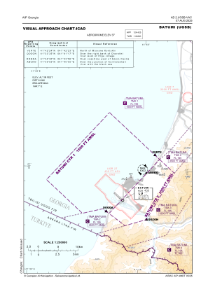
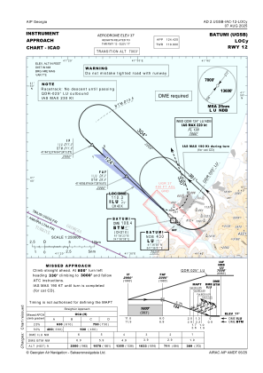
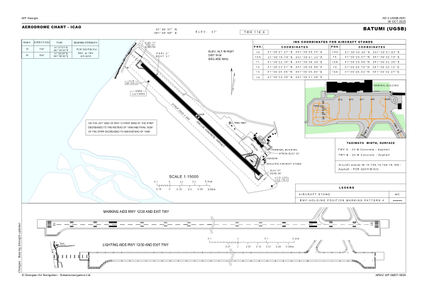
Coordinates: N41°36'37" E41°35'58"
Elevation is 37 feet MSL.
Magnetic variation is 7° East View others Airports in Adjara
Operational data
Special qualification required
Current time UTC:
Current local time:
Weather
METAR: UGSB 111800Z 13029G41KT 9999 FEW032 BKN100 20/12 Q1006 NOSIG
TAF: TAF UGSB 111700Z 1118/1218 12029KT 9999 FEW030 BKN080 TX18/1118Z TN14/1202Z BECMG 1119/1121 22013KT SCT020CB BKN050 TEMPO 1120/1206 22020G35KT 4000 TSRA SCT010 BKN020CB TEMPO 1206/1213 23023KT 4000 SHRA SCT010 BKN020CB
Communications frequencies: [VIEW]
Runways:
| RWY identifier | QFU | Length (ft) | Width (ft) | Surface | LDA (ft) |
| 12 | 131° | 8202 | 148 | CONC+ASPH | 8202 |
| 30 | 311° | 8202 | 148 | CONC+ASPH | 8202 |
Airport contact information
Address: Batumi Georgia