


UGSA - Natakhtari
Located in Mtskheta, Georgia
ICAO - , IATA -
Data provided by AirmateGeneral information
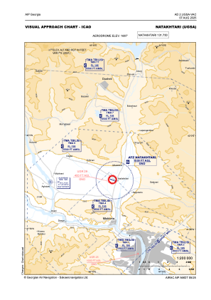
Coordinates: N41°55'14" E44°43'10"
Elevation is 1687 feet MSL.
Magnetic variation is 7° East View others Airports in Mtskheta-Mtianeti
Operational data
Special qualification required
Current time UTC:
Current local time:
Weather at : UGTB - Tbilisi/Tbilisi ( 34 km )
METAR: UGTB 131830Z 31014KT 9999 OVC068 13/08 Q1010 NOSIG
TAF: TAF UGTB 131700Z 1318/1418 31021KT 9999 SCT050CB BKN070 TX14/1412Z TN10/1402Z TEMPO 1318/1321 31011KT TEMPO 1322/1404 4900 SHRA SCT014 BKN020CB OVC030 TEMPO 1408/1412 RA BKN012 OVC025 TEMPO 1412/1415 TSRA BKN030CB
Communications frequencies: [VIEW]
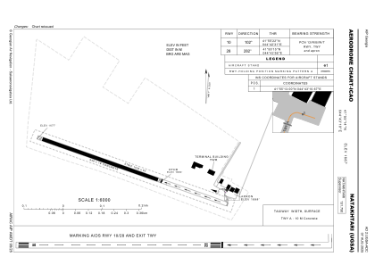
Runways:
| RWY identifier | QFU | Length (ft) | Width (ft) | Surface | LDA (ft) |
| 10 | 109° | 3110 | 59 | CONC | 3110 |
| 28 | 289° | 3110 | 59 | CONC | 2034 |
Airport contact information
Address: Mtskheta Georgia