


TS95 - Alvie Cole Ranch
Located in Sterling City, United States
ICAO - TS95, IATA -
Data provided by AirmateGeneral information
Coordinates: N31°38'37" W100°58'10"
Elevation is 2444 feet MSL.
Magnetic variation is 08° East View others Airports in Texas
Operational data
Special qualification required
Current time UTC:
Current local time:
Weather at : KSJT - San Angelo Rgnl/Mathis Fld ( 55 km )
METAR: KSJT 091251Z 00000KT 10SM OVC021 19/10 A2976 RMK AO2 SLP051 T01940100
TAF: KSJT 091138Z 0912/1012 VRB05KT P6SM OVC015 FM091400 25010KT P6SM VCSH BKN015 FM091600 28011G15KT P6SM SKC FM092300 02018G25KT P6SM FEW250 FM100900 04010KT P6SM SKC
Communications frequencies: [VIEW]
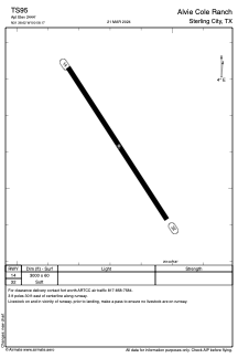
Runways:
| RWY identifier | QFU | Length (ft) | Width (ft) | Surface | LDA (ft) |
| 14 | 146° | 3000 | 60 | OTHER | |
| 32 | 326° | 3000 | 60 | OTHER |
Airport contact information
Address: Sterling City United States