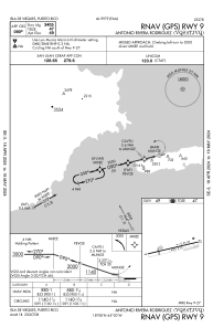


TJVQ - Antonio Rivera Rodriguez
Located in Isla De Vieques, Puerto Rico
ICAO - VQS, IATA - VQS
Data provided by AirmateGeneral information
Coordinates: N18°8'5" W65°29'37"
Elevation is 49 feet MSL.
Magnetic variation is -13° East View others Airports in (unassigned)
Operational data
Special qualification required
Current time UTC:
Current local time:
Weather at : TIST - Cyril E King ( 59 km )
METAR: TIST 192053Z 14008KT 10SM FEW030 A2992 RMK AO2 SLP134 6//// 56017 PNO $
TAF: TIST 191725Z 1918/2018 13012KT P6SM SCT025 SCT050 FM192200 08008KT P6SM FEW025 SCT060 FM201400 14012KT P6SM VCSH SCT030 SCT050 AMD NOT SKED
Communications frequencies: [VIEW]
Runways:
| RWY identifier | QFU | Length (ft) | Width (ft) | Surface | LDA (ft) |
| 09 | 76° | 4301 | 75 | ASPH | 3405 |
| 27 | 257° | 4301 | 75 | ASPH | 3405 |
Airport contact information
Address: Isla De Vieques Puerto Rico