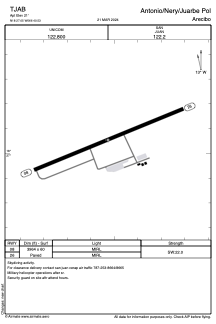


TJAB - Antonio/Nery/Juarbe Pol
Located in Arecibo, Puerto Rico
ICAO - ABO, IATA - ARE
Data provided by AirmateGeneral information
Coordinates: N18°27'3" W66°40'32"
Elevation is 21 feet MSL.
Magnetic variation is -10° East View others Airports in (unassigned)
Operational data
Special qualification required
Current time UTC:
Current local time:
Weather at : TJBQ - Rafael Hernandez ( 48 km )
METAR: TJBQ 250250Z 00000KT 10SM SCT020 26/22 A2999
TAF: TJBQ 242340Z 2500/2524 10005KT P6SM -RA VCSH SCT025 BKN050 OVC100 FM250230 VRB03KT P6SM SCT025 SCT050 BKN100 PROB30 2506/2510 VRB12G18KT 4SM SHRA BKN025 BKN050 FM251300 05009KT P6SM FEW030 SCT060 BKN100 FM251700 04010KT P6SM VCSH SCT025 BKN050 AMD NOT SKED 2502/2511
Communications frequencies: [VIEW]
Runways:
| RWY identifier | QFU | Length (ft) | Width (ft) | Surface | LDA (ft) |
| 08 | 68° | 3964 | 60 | ASPH | |
| 26 | 248° | 3964 | 60 | ASPH |
Airport contact information
Address: Arecibo Puerto Rico