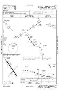


T69 - Alfred C 'Bubba' Thomas
Located in Sinton, United States
ICAO - T69, IATA -
Data provided by AirmateGeneral information
Coordinates: N28°2'19" W97°32'33"
Elevation is 48 feet MSL.
Magnetic variation is 06° East View others Airports in Texas
Operational data
Special qualification required
Current time UTC:
Current local time:
Weather at : KCRP - Corpus Christi Intl ( 30 km )
METAR: KCRP 091551Z 14008KT 5SM HZ FEW013 BKN018 OVC190 29/27 A2968 RMK AO2 SLP050 T02940267
TAF: KCRP 091515Z 0915/1012 13008KT 4SM HZ FEW010 OVC015 TEMPO 0915/0918 SCT020 FM091800 10011KT P6SM FEW025 BKN250 FM100800 VRB06KT 5SM HZ BR BKN018
Communications frequencies: [VIEW]
Runways:
| RWY identifier | QFU | Length (ft) | Width (ft) | Surface | LDA (ft) |
| 03 | 41° | 3100 | 50 | GRASS | |
| 21 | 221° | 3100 | 50 | GRASS | |
| 14 | 146° | 4323 | 55 | ASPH | |
| 32 | 326° | 4323 | 55 | ASPH |
Airport contact information
Address: Sinton United States
