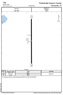


T45 - Panhandle-Carson County
Located in Panhandle, United States
ICAO - T45, IATA -
Data provided by AirmateGeneral information
Coordinates: N35°21'42" W101°21'54"
Elevation is 3454 feet MSL.
Magnetic variation is 08° East View others Airports in Texas
Operational data
Special qualification required
Current time UTC:
Current local time:
Weather at : KAMA - Rick Husband Amarillo Intl ( 35 km )
METAR: KAMA 091153Z 05009KT 10SM CLR 08/00 A2994 RMK AO2 SLP098 T00830000 10161 20072 53022
TAF: KAMA 091124Z 0912/1012 07011KT P6SM SKC FM091400 07014G24KT P6SM SKC FM100200 07010KT P6SM SCT250 FM100900 02010KT P6SM SCT250
Communications frequencies: [VIEW]
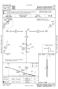
Runways:
| RWY identifier | QFU | Length (ft) | Width (ft) | Surface | LDA (ft) |
| 17 | 180° | 4404 | 60 | ASPH | |
| 35 | 360° | 4404 | 60 | ASPH |
Airport contact information
Address: Panhandle United States