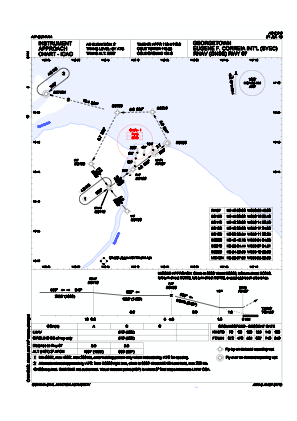


SYEC - Eugene F. Correia International Airport
Located in Georgetown, Guyana
ICAO - , IATA - OGL
Data provided by AirmateGeneral information
Coordinates: N6°48'21" W58°6'27"
Elevation is 6 feet MSL.
View others Airports in Demerara-Mahaica
Operational data
Special qualification required
Current time UTC:
Current local time:
Weather
TAF: TAF SYEC 160500Z 1606/1706 06008KT 9999 SCT017 SCT036 BKN080 TEMPO 1608/1612 5000 SHRA RA BKN032 BKN060 BECMG 1612/1614 06010KT 9999 BKN020 BKN090
Communications frequencies: [VIEW]
Runways:
| RWY identifier | QFU | Length (ft) | Width (ft) | Surface | LDA (ft) |
| 07 | 53° | 4201 | 98 | UNK | |
| 25 | 233° | 4201 | 98 | UNK |
Airport contact information
Address: Georgetown Guyana