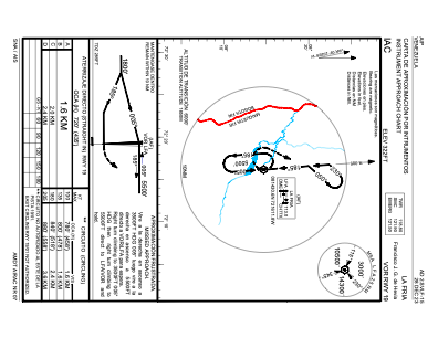
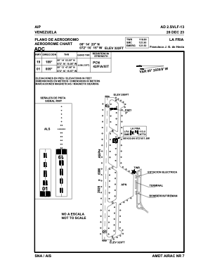


SVLF - Francisco Javier Garcia Hevia, La Fria
Located in La Fria, Venezuela
ICAO - SVLF, IATA - LFR
Data provided by AirmateGeneral information
Coordinates: N8°14'20" W72°16'15"
Elevation is 322 feet MSL.
Magnetic variation is -10° East View others Airports in Tachira
Operational data
Special qualification required
Current time UTC:
Current local time:
Weather at : SKCC - Cucuta-Camilo Daza ( 44 km )
METAR: SKCC 171100Z VRB03KT 9999 SCT022 SCT080 25/20 Q1014
TAF: TAF SKCC 171030Z 1712/1812 VRB02KT 9999 SCT018 BECMG 1716/1718 36010KT TX33/1719Z TN24/1810Z
Communications frequencies: [VIEW]
Runways:
| RWY identifier | QFU | Length (ft) | Width (ft) | Surface | LDA (ft) |
| 01 | 360° | 6637 | 188 | ASPH | 6644 |
| 19 | 180° | 6637 | 188 | ASPH | 6644 |
Airport contact information
Address: La Fria Venezuela