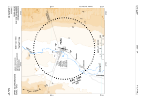


SPUR - Capitan Fap Guillermo Concha Iberico
Located in Piura, Peru
ICAO - SPUR, IATA - PIU
Data provided by AirmateGeneral information
Coordinates: S5°12'21" W80°36'59"
Elevation is 116 feet MSL.
View others Airports in Piura Region
Operational data
Special qualification required
Current time UTC:
Current local time:
Weather
METAR: SPUR 180700Z 16007KT CAVOK 21/17 Q1013 RMK PP000
TAF: TAF SPUR 180510Z 1806/1906 16008KT CAVOK TX31/1820Z TN20/1811Z BECMG 1816/1818 22015KT BECMG 1903/1905 16008KT
Communications frequencies: [VIEW]
Runways:
| RWY identifier | QFU | Length (ft) | Width (ft) | Surface | LDA (ft) |
| 01 | 13° | 8202 | 148 | ASP | |
| 19 | 193° | 8202 | 148 | ASP |
Airport contact information
Address: Piura Peru