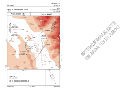


SPLH - Las Dunas
Located in Ica, Peru
ICAO - , IATA -
Data provided by AirmateGeneral information
Coordinates: S14°2'7" W75°45'37"
Elevation is 1358 feet MSL.
View others Airports in Ica Region
Operational data
Special qualification required
Current time UTC:
Current local time:
Weather at : SPSO - Aeropuerto Internacional De Pisco ( 59 km )
METAR: SPSO 240600Z VRB02KT 4000 BR OVC007 18/16 Q1015 RMK PP000
TAF: SPSO 240500Z 2406/2506 VRB02KT 3500 BR OVC006 TX20/2419Z TN14/2411Z BECMG 2408/2410 1000 OVC002 BECMG 2413/2415 30012KT 8000 NSW NSC BECMG 2420/2422 22012KT BECMG 2504/2506 VRB02KT 4000 BR OVC006
Communications frequencies: [VIEW]
Runways:
| RWY identifier | QFU | Length (ft) | Width (ft) | Surface | LDA (ft) |
| 15 | 0° | 4846 | 75 | UNK | |
| 33 | 0° | 4846 | 75 | UNK |
Airport contact information
Address: Ica Peru