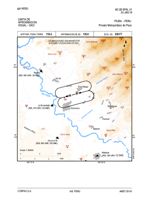


SPAL - Metropolitano De Piura
Located in , Peru
ICAO - SPAL, IATA -
Data provided by AirmateGeneral information
Coordinates: S5°4'4" W80°8'51"
Elevation is 338 feet MSL.
View others Airports in San Martín Region
Operational data
Special qualification required
Current time UTC:
Current local time:
Weather at : SPUR - Capitan Fap Guillermo Concha Iberico ( 54 km )
METAR: SPUR 190500Z 17009KT 9999 OVC020 21/17 Q1014 RMK PP000
TAF: TAF SPUR 190500Z 1906/2006 15007KT 9999 OVC020 TX30/1919Z TN20/1911Z TEMPO 1910/1913 BKN010 BECMG 1914/1916 CAVOK BECMG 1918/1920 22016KT
Communications frequencies: [VIEW]
Runways:
| RWY identifier | QFU | Length (ft) | Width (ft) | Surface | LDA (ft) |
| 08 | 0° | 2625 | 59 | UNK | |
| 26 | 0° | 2625 | 59 | UNK |
Airport contact information
Address: Peru