


SN42 - Fazenda Santa Maria
Located in Tacuru, United States
ICAO - SN42, IATA -
Data provided by AirmateGeneral information
Coordinates: S23°42'5" W54°47'24"
Elevation is 1000 feet MSL.
Magnetic variation is -17.483333333° East View others Airports in Kansas
Operational data
Special qualification required
Current time UTC:
Current local time:
Weather at : - ( 0 km )
METAR: CYQA 080922Z AUTO 11003KT 080V170 5SM -RA BR SCT027 OVC033 10/09 A2949 RMK PCPN 0.8MM PAST HR SLP991
Communications frequencies: [VIEW]
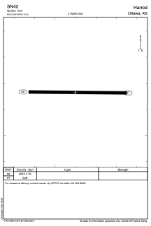
Runways:
| RWY identifier | QFU | Length (ft) | Width (ft) | Surface | LDA (ft) |
| 09 | 90° | 2210 | 75 | GRASS | |
| 27 | 270° | 2210 | 75 | GRASS | |
| 16 | 0° | 3609 | 98 | EARTH | |
| 34 | 0° | 3609 | 98 | EARTH |
Airport contact information
Address: Tacuru United States