


SLTR - Tte. Av. Jorge Henrich Arauz
Located in Trinidad, Bolivia
ICAO - SLTR, IATA - TDD
Data provided by AirmateGeneral information
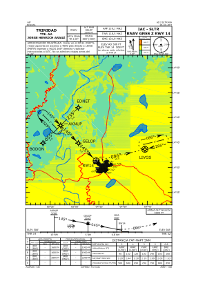
Coordinates: S14°49'10" W64°55'8"
Elevation is 516 feet MSL.
View others Airports in El Beni
Operational data
Special qualification required
Current time UTC:
Current local time:
Weather
TAF: TAF SLTR 140400Z 1406/1506 14005KT 9999 BKN008 BKN070 TX21/1419Z TN17/1410Z TEMPO 1410/1413 3000 BR BKN005 BECMG 1413/1415 15010KT BKN010 BECMG 1500/1502 00000KT BKN005
Communications frequencies: [VIEW]
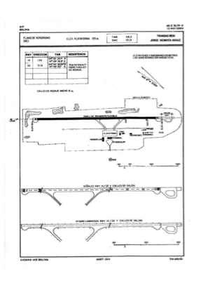
Runways:
| RWY identifier | QFU | Length (ft) | Width (ft) | Surface | LDA (ft) |
| 14 | 135° | 7874 | 98 | ASP | |
| 32 | 315° | 7874 | 98 | ASP |
Airport contact information
Address: Trinidad Bolivia