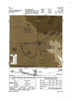


SLLP - El Alto/ Intl
Located in La Paz, Bolivia
ICAO - SLLP, IATA - LPB
Data provided by AirmateGeneral information
Coordinates: S16°30'45" W68°11'32"
Elevation is 13314 feet MSL.
View others Airports in La Paz
Operational data
Special qualification required
Current time UTC:
Current local time:
Weather
METAR: SLLP 221300Z 26004KT 9999 FEW013 10/M01 Q1040
TAF: TAF COR SLLP 221100Z 2212/2312 34005KT 9999 FEW013 TX17/2220Z TNM01/2310Z BECMG 2213/2216 28012KT BECMG 2302/2304 06005KT
Communications frequencies: [VIEW]
Runways:
| RWY identifier | QFU | Length (ft) | Width (ft) | Surface | LDA (ft) |
| 10 | 91° | 13124 | 151 | CON | |
| 28 | 272° | 13124 | 151 | CON |
Airport contact information
Address: La Paz Bolivia