

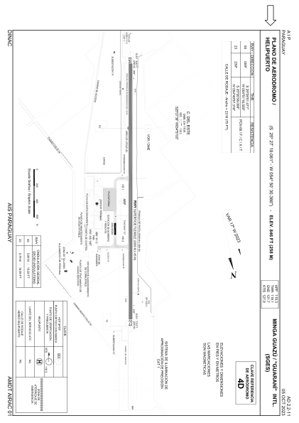


SGES - Minga Guazu / Guarani / Intl
Located in Minga Guazu, Paraguay
ICAO - SGES, IATA - AGT
Data provided by AirmateGeneral information
Coordinates: S25°27'19" W54°50'30"
Elevation is 846 feet MSL.
Magnetic variation is -17° East View others Airports in Alto Paraná Department
Operational data
Special qualification required
Current time UTC:
Current local time:
Weather
METAR: SGES 151230Z 16004KT 9999 SCT027 11/09 Q1019
TAF: TAF SGES 150439Z 1506/1606 21006KT 9999 SCT030 TX19/1518Z TN12/1509Z PROB30 TEMPO 1507/1510 8000 BKN012 BECMG 1512/1516 VRB04KT 9999 SCT020
Communications frequencies: [VIEW]
Runways:
| RWY identifier | QFU | Length (ft) | Width (ft) | Surface | LDA (ft) |
| 05 | 41° | 11129 | 144 | ASPH | 11119 |
| 23 | 221° | 11129 | 144 | ASPH | 11119 |
Airport contact information
Address: Minga Guazu Paraguay