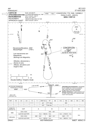
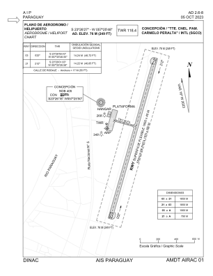


SGCO - Tte. Cnel. Pam Carmelo Peralta
Located in Concepcion, Paraguay
ICAO - SGCO, IATA - CIO
Data provided by AirmateGeneral information
Coordinates: S23°26'27" W57°25'48"
Elevation is 249 feet MSL.
Magnetic variation is -16° East View others Airports in Concepción Department
Operational data
Special qualification required
Current time UTC:
Current local time:
Weather
TAF: TAF SGCO 150439Z 1506/1606 18010KT 9999 BKN020 TX19/1518Z TN14/1509Z PROB30 TEMPO 1507/1511 9000 BKN010 OVC018 BECMG 1512/1516 9999 BKN018
Communications frequencies: [VIEW]
Runways:
| RWY identifier | QFU | Length (ft) | Width (ft) | Surface | LDA (ft) |
| 03 | 16° | 6050 | 128 | ASPH | 6070 |
| 21 | 196° | 6050 | 128 | ASPH | 6070 |
Airport contact information
Address: Concepcion Paraguay