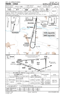
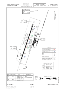


SCQP - La Araucania
Located in Freire, Chile
ICAO - , IATA -
Data provided by AirmateGeneral information
Coordinates: S38°55'33" W72°39'6"
Elevation is 321 feet MSL.
Magnetic variation is 6° East View others Airports in Araucanía
Operational data
Special qualification required
Current time UTC:
Current local time:
Weather
METAR: SCQP 162200Z VRB01KT 9999 FEW040 09/07 Q1021
TAF: TAF SCQP 161603Z 1618/1718 36004KT 9999 BKN040 TX14/1619Z TN01/1712Z BECMG 1622/1624 16004KT SCT035 TEMPO 1702/1712 VRB02KT 0700 FG VV002 BECMG 1714/1716 CAVOK
Communications frequencies: [VIEW]
Runways:
| RWY identifier | QFU | Length (ft) | Width (ft) | Surface | LDA (ft) |
| 01 | 0° | 8005 | 148 | UNK | |
| 19 | 0° | 8005 | 148 | UNK |
Airport contact information
Address: Freire Chile