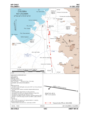


SCCL - Caldera
Located in Caldera, Chile
ICAO - SCCL, IATA -
Data provided by AirmateGeneral information
Coordinates: S27°4'41" W70°47'44"
Elevation is 180 feet MSL.
Magnetic variation is -2° East View others Airports in Atacama
Operational data
Special qualification required
Current time UTC:
Current local time:
Weather at : SCAT - Desierto De Atacama ( 20 km )
METAR: SCAT 160200Z AUTO 13004KT 9999 NCD 09/06 Q1017
TAF: TAF SCAT 152200Z 1600/1624 24004KT CAVOK TN10/1610Z TX17/1618Z BECMG 1601/1603 BKN020 BECMG 1604/1606 09004KT BECMG 1614/1616 25006KT CAVOK
Communications frequencies: [VIEW]
Runways:
| RWY identifier | QFU | Length (ft) | Width (ft) | Surface | LDA (ft) |
| 11 | 109° | 3937 | 81 | ASPH | |
| 29 | 289° | 3937 | 81 | ASPH |
Airport contact information
Address: Caldera Chile