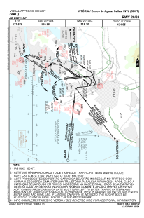
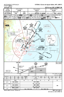
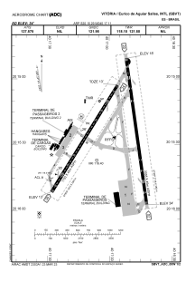


SBVT - Eurico De Aguiar Salles
Located in Vitória, Brazil
ICAO - SBVT, IATA - VIX
Data provided by AirmateGeneral information
Coordinates: S20°15'29" W40°17'11"
Elevation is 34 feet MSL.
Magnetic variation is -23.85° East View others Airports in Espírito Santo
Operational data
Special qualification required
Current time UTC:
Current local time:
Weather
METAR: SBVT 181100Z 32004KT CAVOK 26/22 Q1017
TAF: TAF SBVT 180920Z 1812/1912 31005KT 9999 SCT020 TX32/1816Z TN21/1908Z BECMG 1812/1814 06010KT BECMG 1815/1818 04015KT BECMG 1821/1823 34007KT RMK PHN
Communications frequencies: [VIEW]
Runways:
| RWY identifier | QFU | Length (ft) | Width (ft) | Surface | LDA (ft) |
| 02 | 352° | 7146 | 919 | ASPH | |
| 20 | 172° | 7146 | 919 | ASPH | |
| 06 | 32° | 6135 | 919 | ASPH | |
| 24 | 212° | 6135 | 919 | ASPH |
Airport contact information
Address: Vitória Brazil
