
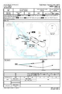


SBTT - Tabatinga
Located in Tabatinga, Brazil
ICAO - SBTT, IATA - TBT
Data provided by AirmateGeneral information
Coordinates: S4°15'2" W69°56'16"
Elevation is 262 feet MSL.
Magnetic variation is -9.806055056° East View others Airports in Amazonas
Operational data
Special qualification required
Current time UTC:
Current local time:
Weather
METAR: SBTT 231300Z 08001KT CAVOK 28/25 Q1014
Communications frequencies: [VIEW]
Runways:
| RWY identifier | QFU | Length (ft) | Width (ft) | Surface | LDA (ft) |
| 12 | 115° | 7448 | 919 | ASPH | |
| 30 | 295° | 7448 | 919 | ASPH |
Airport contact information
Address: Tabatinga Brazil