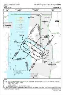
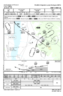


SBPJ - Brigadeiro Lysias Rodrigues
Located in Palmas, Brazil
ICAO - SBPJ, IATA - PMW
Data provided by AirmateGeneral information
Coordinates: S10°17'24" W48°21'28"
Elevation is 774 feet MSL.
Magnetic variation is -21.516666667° East View others Airports in Tocatins
Operational data
Special qualification required
Current time UTC:
Current local time:
Weather
METAR: SBPJ 230400Z 09005KT CAVOK 28/21 Q1014
TAF: TAF SBPJ 230325Z 2306/2406 09007KT 9999 FEW023 TN25/2309Z TX34/2317Z BECMG 2306/2308 12007KT BECMG 2312/2314 09010KT BECMG 2318/2321 15005KT BECMG 2400/2402 12007KT RMK PHC
Communications frequencies: [VIEW]
Runways:
| RWY identifier | QFU | Length (ft) | Width (ft) | Surface | LDA (ft) |
| 14 | 124° | 8596 | 919 | ASPH | |
| 32 | 304° | 8596 | 919 | ASPH |
Airport contact information
Address: Palmas Brazil