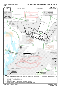
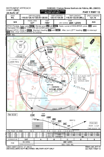
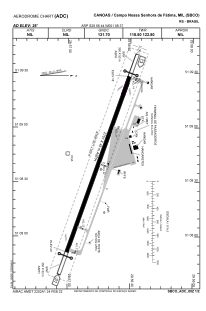


SBCO - Campo Nossa Senhora De Fátima
Located in Canoas, Brazil
ICAO - SBCO, IATA - QNS
Data provided by AirmateGeneral information
Coordinates: S29°56'44" W51°8'37"
Elevation is 26 feet MSL.
Magnetic variation is -17.55° East View others Airports in Rio Grande do Sul
Operational data
Special qualification required
Current time UTC:
Current local time:
Weather
METAR: SBCO 181200Z 00000KT 9999 FEW012 13/13 Q1021
TAF: TAF SBCO 180300Z 1806/1818 17007KT 8000 SCT010 TN12/1808Z TX16/1816Z BECMG 1810/1812 9999 SCT030 BECMG 1813/1815 BKN035 RMK PEG
Communications frequencies: [VIEW]
Runways:
| RWY identifier | QFU | Length (ft) | Width (ft) | Surface | LDA (ft) |
| 13 | 0° | 9026 | 148 | ASPH | |
| 31 | 0° | 9026 | 148 | ASPH |
Airport contact information
Address: Canoas Brazil
