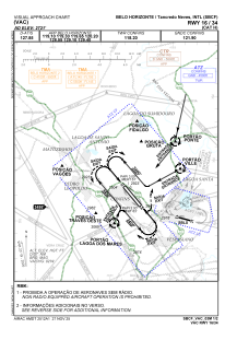
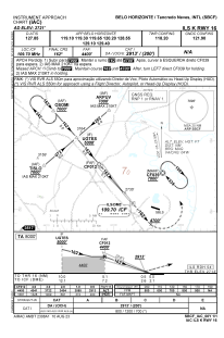
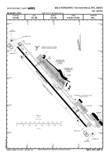


SBCF - Tancredo Neves
Located in Belo Horizonte, Brazil
ICAO - SBCF, IATA - CNF
Data provided by AirmateGeneral information
Coordinates: S19°37'28" W43°58'19"
Elevation is 2721 feet MSL.
Magnetic variation is -23.05° East View others Airports in Minas Gerais
Operational data
Special qualification required
Current time UTC:
Current local time:
Weather
METAR: SBCF 180900Z 13001KT CAVOK 16/14 Q1021
TAF: TAF SBCF 180800Z 1812/1912 06008KT CAVOK TX29/1817Z TN16/1909Z BECMG 1814/1816 02002KT FEW040 BECMG 1816/1818 35004KT SCT040 BECMG 1818/1820 09004KT FEW040 BECMG 1821/1823 06004KT CAVOK BECMG 1900/1902 13002KT BECMG 1903/1905 16004KT BECMG 1905/1907 13005KT BECMG 1910/1912 09008KT RMK PHG
Communications frequencies: [VIEW]
Runways:
| RWY identifier | QFU | Length (ft) | Width (ft) | Surface | LDA (ft) |
| 16 | 139° | 12205 | 984 | ASPH | |
| 34 | 319° | 12205 | 984 | ASPH |
Airport contact information
Address: Belo Horizonte Brazil