


SBBU - Bauru
Located in Bauru, Brazil
ICAO - SBBU, IATA - BAU
Data provided by AirmateGeneral information
Coordinates: S22°20'42" W49°3'14"
Elevation is 2025 feet MSL.
Magnetic variation is -21.016666667° East View others Airports in São Paulo
Operational data
Special qualification required
Current time UTC:
Current local time:
Weather
TAF: TAF SBBU 252122Z 2600/2612 15010KT 8000 SCT005 TX23/2600Z TN17/2606Z TEMPO 2606/2612 3000 RA BR OVC002 RMK PGE
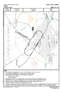
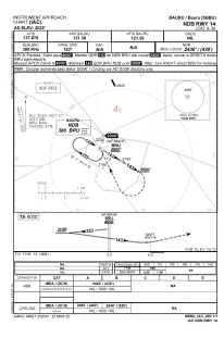
Communications frequencies: [VIEW]
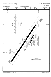
Runways:
| RWY identifier | QFU | Length (ft) | Width (ft) | Surface | LDA (ft) |
| 14 | 0° | 5318 | 492 | ASPH | |
| 32 | 0° | 5318 | 492 | ASPH |
Airport contact information
Address: Bauru Brazil
