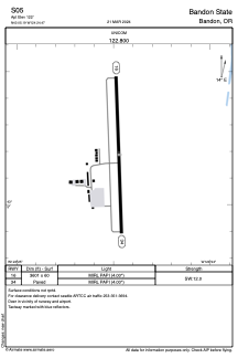


S05 - Bandon State
Located in Bandon, United States
ICAO - S05, IATA -
Data provided by AirmateGeneral information
Coordinates: N43°5'11" W124°24'28"
Elevation is 122 feet MSL.
Magnetic variation is 18° East View others Airports in Oregon
Operational data
Special qualification required
Current time UTC:
Current local time:
Weather at : KOTH - Southwest Oregon Rgnl ( 39 km )
METAR: KOTH 081456Z 03005KT 10SM CLR 08/06 A3041 RMK AO2 SLP296 T00780056 53006
TAF: KOTH 081135Z 0812/0912 03006KT P6SM SKC FM081700 36011KT P6SM SKC FM081900 36017G23KT P6SM SKC FM090600 36006KT P6SM SKC
Communications frequencies: [VIEW]
Runways:
| RWY identifier | QFU | Length (ft) | Width (ft) | Surface | LDA (ft) |
| 16 | 178° | 3601 | 60 | ASPH | |
| 34 | 358° | 3601 | 60 | ASPH |
Airport contact information
Address: Bandon United States