


RJFS - Saga
Located in Saga, Japan
ICAO - RJFS, IATA - HSG
Data provided by AirmateGeneral information
Coordinates: N33°8'59" E130°18'8"
Elevation is 6 feet MSL.
View others Airports in Saga Prefecture
Operational data
Special qualification required
Current time UTC:
Current local time:
Weather
METAR: RJFS 140000Z 02003KT 300V080 CAVOK 19/10 Q1016
TAF: TAF RJFS 132306Z 1400/1506 03005KT 9999 FEW030 BECMG 1401/1403 23007KT BECMG 1500/1503 17007KT
Communications frequencies: [VIEW]
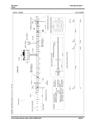
Runways:
| RWY identifier | QFU | Length (ft) | Width (ft) | Surface | LDA (ft) |
| 11 | 99° | 6562 | 148 | ASP | |
| 29 | 279° | 6562 | 148 | ASP |
Airport contact information
Address: Saga Japan