


RCFN - Taitung/Fongnian
Located in Taitung, Taiwan, Province of China
ICAO - RCFN, IATA - TTT
Data provided by AirmateGeneral information
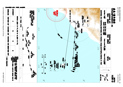
Coordinates: N22°45'19" E121°6'1"
Elevation is 143 feet MSL.
View others Airports in Taitung County
Operational data
Special qualification required
Current time UTC:
Current local time:
Weather
METAR: RCFN 162200Z 34003KT 290V050 9999 FEW010 BKN100 22/19 Q1015 NOSIG RMK A2998
TAF: TAF RCFN 161700Z 1618/1718 34005KT 9999 FEW015 BKN032 BECMG 1700/1702 06008KT TEMPO 1705/1711 5000 SHRA FEW012 BKN018 FEW020TCU BECMG 1711/1713 34005KT
Communications frequencies: [VIEW]
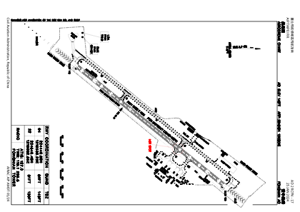
Runways:
| RWY identifier | QFU | Length (ft) | Width (ft) | Surface | LDA (ft) |
| 04 | 39° | 7999 | 148 | PEM | |
| 22 | 219° | 7999 | 148 | PEM |
Airport contact information
Address: Taitung Taiwan, Province of China