


PHLI - Lihue
Located in Lihue,
ICAO - LIH, IATA - LIH
Data provided by AirmateGeneral information
Coordinates: N21°58'34" W159°20'20"
Elevation is 152 feet MSL.
Magnetic variation is 11° East View others Airports in Hawaii
Operational data
Special qualification required
Current time UTC:
Current local time:
Weather
METAR: PHLI 090355Z 28005KT 10SM SCT026 BKN036 OVC050 22/20 A2998 RMK AO2 T02170200
TAF: PHLI 090145Z 0902/0924 07011KT P6SM -SHRA SCT025 BKN035 FM090600 05009KT P6SM SCT025 BKN050 FM091200 VRB06KT P6SM SCT025 SCT045 FM092000 06009KT P6SM SCT025 SCT050
Communications frequencies: [VIEW]
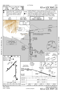
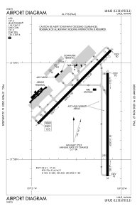
Runways:
| RWY identifier | QFU | Length (ft) | Width (ft) | Surface | LDA (ft) |
| 03 | 45° | 6500 | 150 | ASPH | 6500 |
| 21 | 225° | 6500 | 150 | ASPH | 6295 |
| 17 | 180° | 6500 | 150 | ASPH | 6500 |
| 35 | 360° | 6500 | 150 | ASPH | 6500 |
| H1 | 0° | 0 | 0 | UNK | |
| H2 | 0° | 0 | 0 | UNK | |
| H3 | 0° | 0 | 0 | UNK |
Airport contact information
Address: Lihue
