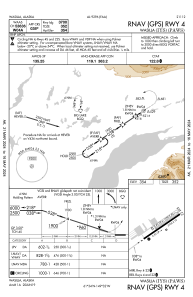


PAWS - Wasilla
Located in Wasilla,
ICAO - IYS, IATA - WWA
Data provided by AirmateGeneral information
Coordinates: N61°34'19" W149°32'22"
Elevation is 354 feet MSL.
Magnetic variation is 18° East View others Airports in Alaska
Operational data
Special qualification required
Current time UTC:
Current local time:
Weather
METAR: PAWS 091156Z AUTO 11003KT 10SM OVC032 01/M01 A2998 RMK AO2 SLP159 60004 70008 T00061006 10022 20006 58008 FZRANO
Communications frequencies: [VIEW]
Runways:
| RWY identifier | QFU | Length (ft) | Width (ft) | Surface | LDA (ft) |
| 04 | 56° | 3700 | 75 | ASPH | |
| 22 | 236° | 3700 | 75 | ASPH | |
| 04S | 56° | 1690 | 60 | OTHER | |
| 22S | 236° | 1690 | 60 | OTHER |
Airport contact information
Address: Wasilla