


PASN - St Paul Island
Located in St Paul Island,
ICAO - SNP, IATA - SNP
Data provided by AirmateGeneral information
Coordinates: N57°9'59" W170°13'21"
Elevation is 66 feet MSL.
Magnetic variation is 10° East View others Airports in Alaska
Operational data
Special qualification required
Current time UTC:
Current local time:
Weather
METAR: PASN 091853Z AUTO 10014KT 10SM OVC027 M02/M07 A2973 RMK AO2 SLP067 T10171072 TSNO
TAF: PASN 091731Z 0918/1018 09012KT P6SM OVC025 FM092100 08019G27KT P6SM OVC025 FM100300 07026G34KT P6SM SCT007 OVC015 FM101200 04025G35KT 6SM BR VCSH OVC015
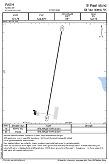
Communications frequencies: [VIEW]
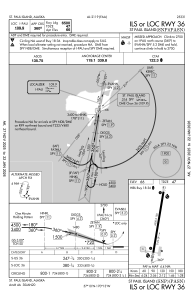
Runways:
| RWY identifier | QFU | Length (ft) | Width (ft) | Surface | LDA (ft) |
| 18 | 190° | 6500 | 150 | ASPH | |
| 36 | 10° | 6500 | 150 | ASPH |
Airport contact information
Address: St Paul Island