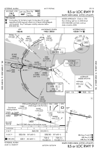


PAOT - Ralph Wien Meml
Located in Kotzebue,
ICAO - OTZ, IATA - OTZ
Data provided by AirmateGeneral information
Coordinates: N66°53'5" W162°35'53"
Elevation is 15 feet MSL.
Magnetic variation is 11° East View others Airports in Alaska
Operational data
Special qualification required
Current time UTC:
Current local time:
Weather
METAR: PAOT 091453Z AUTO 27007KT 10SM OVC055 M03/M03 A2982 RMK AO2 SLP097 60000 T10331033 53001 TSNO
TAF: PAOT 091122Z 0912/1012 22004KT P6SM VCSH OVC050 FM092000 27006KT 6SM -SN BR OVC025 FM100000 29008KT 4SM -SN BR OVC015
Communications frequencies: [VIEW]
Runways:
| RWY identifier | QFU | Length (ft) | Width (ft) | Surface | LDA (ft) |
| 09 | 102° | 6300 | 150 | ASPH | 5900 |
| 27 | 282° | 6300 | 150 | ASPH | 5900 |
| 18 | 194° | 3876 | 90 | GRAVEL | |
| 36 | 14° | 3876 | 90 | GRAVEL |
Airport contact information
Address: Kotzebue