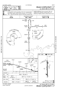


PAMC - Mc Grath
Located in Mc Grath,
ICAO - MCG, IATA - MCG
Data provided by AirmateGeneral information
Coordinates: N62°57'10" W155°36'25"
Elevation is 343 feet MSL.
Magnetic variation is 19° East View others Airports in Alaska
Operational data
Special qualification required
Current time UTC:
Current local time:
Weather
METAR: PAMC 091440Z AUTO 19004KT 3SM -SN BR OVC028 M02/M04 A2992 RMK AO2 P0001 T10221044 TSNO
TAF: PAMC 091236Z 0913/1012 21013G20KT 3SM -SN BR OVC024 FM091800 21010G18KT 6SM -RA BR SCT025 OVC050 FM092000 25006KT P6SM OVC050
Communications frequencies: [VIEW]
Runways:
| RWY identifier | QFU | Length (ft) | Width (ft) | Surface | LDA (ft) |
| 05 | 68° | 2000 | 60 | GRAVEL | |
| 23 | 248° | 2000 | 60 | GRAVEL | |
| 16 | 179° | 5936 | 100 | ASPH | 4843 |
| 34 | 359° | 5936 | 100 | ASPH | 4843 |
Airport contact information
Address: Mc Grath