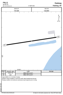


PALG - Kalskag
Located in Kalskag,
ICAO - KLG, IATA - KLG
Data provided by AirmateGeneral information
Coordinates: N61°32'9" W160°20'44"
Elevation is 63 feet MSL.
Magnetic variation is 10° East View others Airports in Alaska
Operational data
Special qualification required
Current time UTC:
Current local time:
Weather
METAR: PALG 091938Z AUTO 09003KT 10SM SCT028 BKN040 OVC048 01/M05 A2986 RMK AO2 FZRANO PNO $
Communications frequencies: [VIEW]
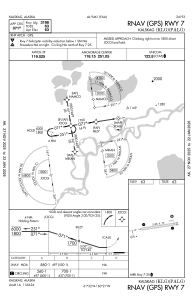
Runways:
| RWY identifier | QFU | Length (ft) | Width (ft) | Surface | LDA (ft) |
| 07 | 81° | 3198 | 75 | GRAVEL | |
| 25 | 261° | 3198 | 75 | GRAVEL |
Airport contact information
Address: Kalskag