


PAKA - Tatitlek
Located in Tatitlek,
ICAO - 7KA, IATA -
Data provided by AirmateGeneral information
Coordinates: N60°52'21" W146°41'28"
Elevation is 62 feet MSL.
Magnetic variation is 20° East View others Airports in Alaska
Operational data
Special qualification required
Current time UTC:
Current local time:
Weather at : PAVD - Valdez Pioneer Fld ( 38 km )
METAR: PAVD 090456Z 00000KT 8SM -RA SCT025 OVC032 05/04 A3005 RMK AO2 SLP175 P0000 T00500039 $
TAF: PAVD 090520Z 0906/1006 VRB03KT P6SM -RA SCT025 BKN045 FM090800 25005KT P6SM -RA SCT015 OVC025 FM091200 VRB03KT P6SM -SHRA SCT009 BKN025 AMD LTD TO CLD VIS AND WIND
Communications frequencies: [VIEW]
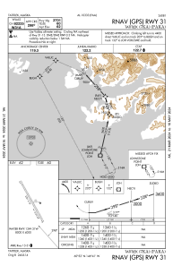
Runways:
| RWY identifier | QFU | Length (ft) | Width (ft) | Surface | LDA (ft) |
| 13 | 151° | 3701 | 75 | GRAVEL | |
| 31 | 331° | 3701 | 75 | GRAVEL | |
| 13W | 0° | 8000 | 4000 | WATER | |
| 31W | 0° | 8000 | 4000 | WATER |
Airport contact information
Address: Tatitlek